Heritage sites tell the stories of our past, preserving architecture, culture, and history for future generations. Whether it’s a centuries-old building, an archaeological landmark, or a historic city centre, these locations require meticulous care when any construction, restoration, or utility work occurs. But what happens when underground utilities must be located in these sensitive areas? Digging blindly is not an option. The risk of damaging fragile structures, disrupting historical artefacts, or altering the integrity of a site is simply too high.
This is where Ground-Penetrating Radar (GPR) technology steps in. GPR offers a non-invasive, highly accurate solution for mapping underground utilities in heritage sites – allowing projects to move forward while ensuring history remains intact. At South-East Scanning, we specialise in utility locating in Brisbane, the Sunshine Coast, and across Queensland, helping heritage conservation teams find the perfect balance between precision and preservation.
Why Utility Locating in Heritage Sites is So Challenging
Unlike modern construction sites, heritage sites pose unique challenges when it comes to locating underground utilities.
✔ Unknown or outdated utility maps – Many heritage sites have been standing for decades or centuries, and records of underground utilities are often incomplete, inaccurate, or non-existent.
✔ Fragile infrastructure – Older pipes, brick tunnels, and even wooden or clay conduits may be present, making traditional excavation methods risky.
✔ Strict preservation regulations – Many heritage sites are protected by local, state, or national laws, requiring extreme caution when conducting underground work.
✔ Unexpected subsurface features – Besides utilities, sites may contain historical foundations, burial sites, or underground storage rooms that must be preserved.
Given these complexities, traditional excavation is not an option. That’s where GPR becomes an essential tool.
How GPR Helps Locate Utilities Without Disturbing Heritage Sites
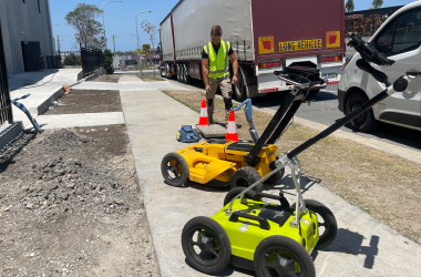
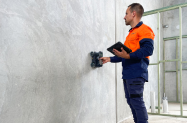
GPR is a non-destructive, ground-based scanning technology that detects buried utilities and structures without requiring digging. It works by sending high-frequency radio waves into the ground, which reflect back when they encounter different materials. By analyzing these reflections, trained specialists can map out pipes, cables, and other underground features—all while leaving the surface untouched.
The Key Benefits of GPR for Heritage Site Utility Locating
✅ Non-Invasive & Non-Destructive – No digging, no drilling, no unnecessary disruption to fragile historical surfaces.
✅ Detects a Wide Range of Utilities – GPR can locate metallic and non-metallic utilities, including old clay or wooden pipes that traditional locators might miss.
✅ Preserves Historical Integrity – Ensures that excavation is only done where necessary, preventing unnecessary disturbance to historically significant areas.
✅ Provides Accurate Depth & Location Data – GPR allows project teams to pinpoint the exact position and depth of underground utilities, avoiding guesswork.
✅ Identifies More Than Just Utilities – GPR can also reveal old building foundations, hidden tunnels, underground voids, or archaeological features, ensuring that critical historical elements are not accidentally destroyed.
Real-World Applications: Heritage Utility Locating in Queensland
At South-East Scanning, we’ve worked on heritage-listed buildings and sites across Brisbane and the Sunshine Coast, providing precise utility locating services that meet both conservation and safety requirements.
For example:
🔹 In Brisbane’s historic CBD, we conducted GPR scans before essential electrical upgrades to locate water pipes, gas lines, and unknown conduits buried under century-old roads.
🔹 In South Brisbane, we assisted a restoration project by mapping underground drainage systems beneath a heritage-listed building, preventing unnecessary excavation.
🔹 At a coastal heritage site near Noosa, our team used GPR to scan for hidden underground structures, allowing archaeologists and engineers to work safely without disturbing protected ground.
These projects required precision, patience, and expertise—qualities defining our approach at South-East Scanning.

The Future of Heritage Conservation & Utility Locating
Responsible infrastructure planning is more critical than ever as cities expand and historical areas evolve. GPR is now essential for ensuring that heritage sites are protected and functional, allowing modern upgrades to occur without damaging the past.
At South-East Scanning, we’re proud to be part of this process, working alongside engineers, conservationists, and project managers to bring innovation to heritage preservation.
Utility locating in heritage sites requires a delicate balance between precision and preservation. With GPR, we can detect and map underground utilities while ensuring the integrity of historic landmarks remains intact.
If you’re planning a project in a heritage-protected area, South-East Scanning has the expertise and technology to do the job safely. Contact us today to learn how we can assist with non-invasive utility locating for your heritage site.
Preserving the past and scanning for the future. 🔍🏛️