When A Council Feared
Its Pool Was Failing,
The Radar Said Otherwise
Facing reported settlement and a fear the pool shells were deteriorating beneath the surface, Southern Downs Regional Council needed an answer before committing to costly intrusive works. South-East Scanning scanned three drained pools and a suspended slab, non-destructively, and found a generally sound facility with a short, specific watch-list.
A regional aquatic centre is a major public asset, and when one starts showing signs of movement, the questions come quickly. Warwick Indoor Recreation and Aquatic Centre had reported settlement and level variation, and there was an understandable concern that the pool shells might be deteriorating where nobody could see. The owner, Southern Downs Regional Council, faced the familiar fork: commit to intrusive investigation and possible major works, or find a way to understand the structure first.
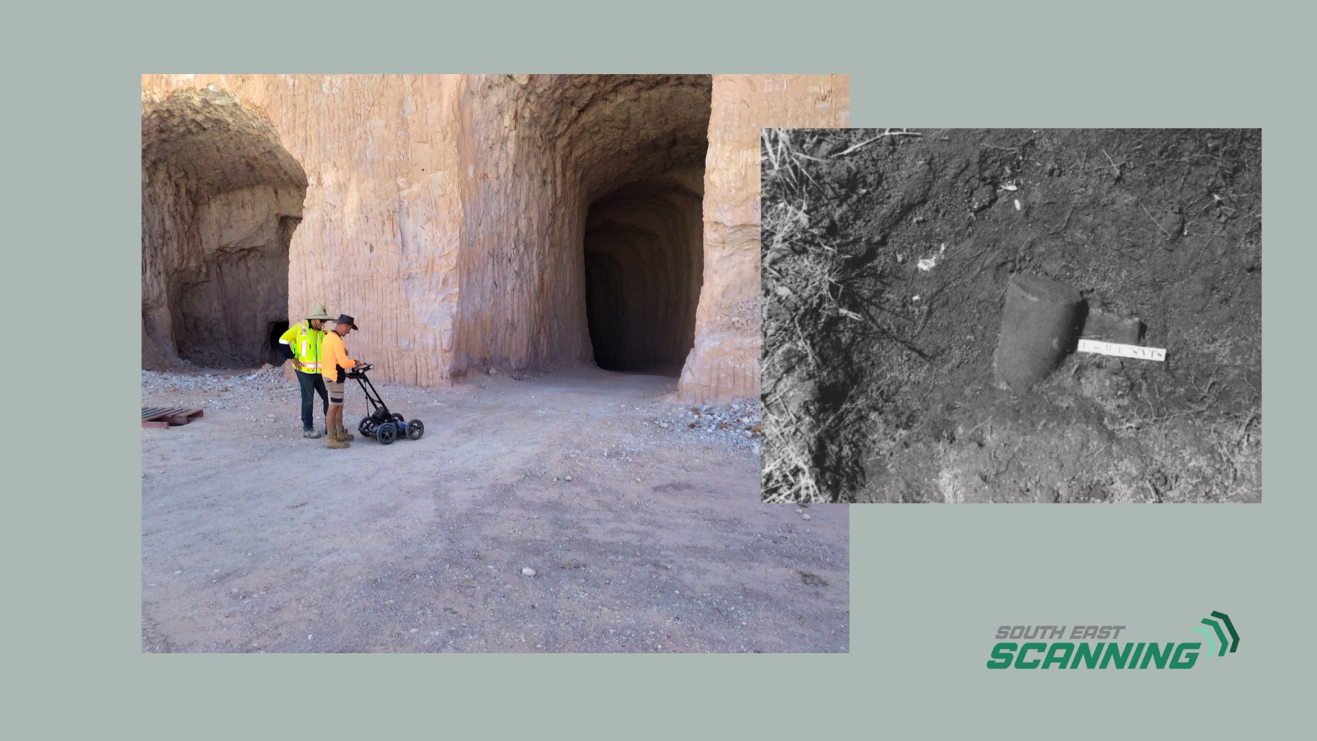
South-East Scanning was engaged to take that first look while the pools were drained for maintenance. The job was to assess the condition of the Olympic pool, children's pool, rapids pool, and surrounding suspended slab, identify any voiding, moisture pathways, or loss of support, and do it all non-destructively, so the investigation answered the question without adding to the repair bill.
The Brief: Confirm Or Rule Out, Before Spending
The council had observed level variation in parts of the facility and wanted to know whether it signalled a structural problem beneath the pool shells. That is exactly the kind of question where guessing is expensive. Cutting into a pool shell to investigate is costly, disruptive, and, if the structure turns out to be sound, avoidable. The brief was to use non-destructive methods to characterise the pool shells and slabs, then advise where, if anywhere, intrusive verification was actually warranted.
Our Approach: One Survey, Read At Three Depths
We can build a detailed picture of a pool shell without touching it, by combining methods that each look at a different depth and reading them together. On this job that meant pairing high-frequency concrete scanning with a dual-frequency GPR system, so a single visit covered everything from the reinforcement near the surface down to the conditions well beneath the slab.
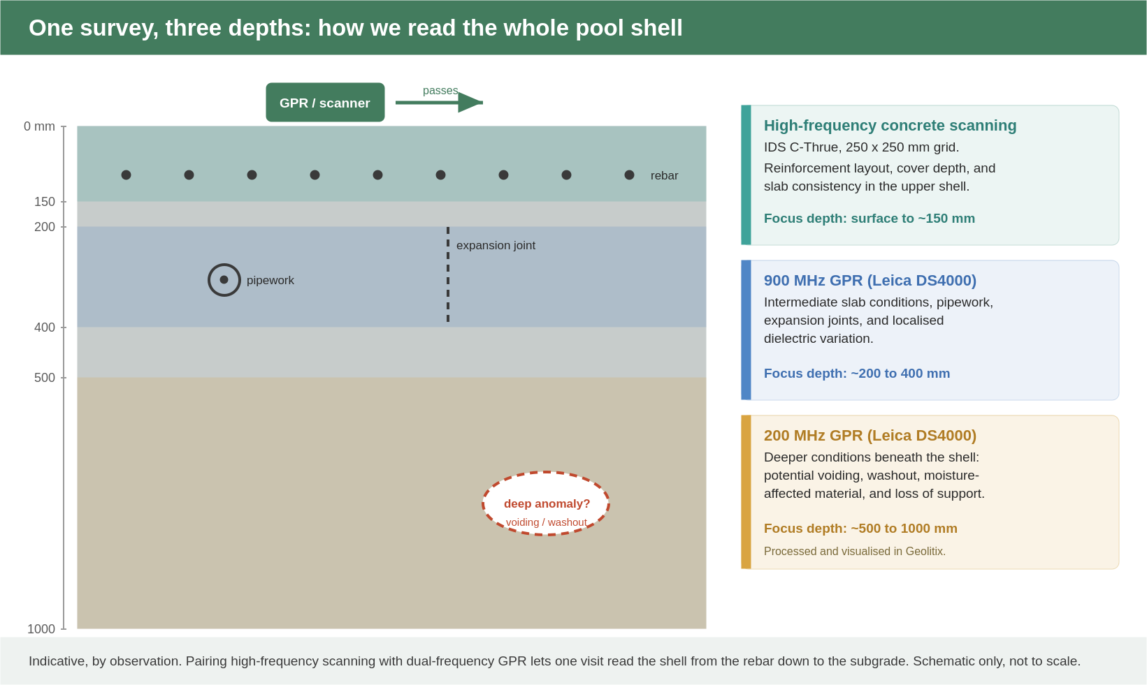 One Survey, Three Depths
High-frequency scanning reads the rebar, while the dual-frequency GPR reaches the intermediate and deep zones beneath the shell.
High-frequency concrete scanning with an IDS C-Thrue, run on a 250 by 250 mm grid, mapped the reinforcement layout, cover depth, and slab consistency in the upper shell. A Leica DS4000 dual-frequency GPR then did the deeper work: its 900 MHz antenna read intermediate slab conditions, pipework, expansion joints, and localised dielectric variation, while its 200 MHz antenna reached the deeper zone where voiding, washout, and loss of support would show up. Grid-based C-scans were collected where the geometry allowed, and representative linear B-scans were used on the curved and figure-eight sections. Everything was processed in Geolitix.
Two honest notes on method. First, the facility is indoors, so satellite positioning was not available; the data was aligned using relative positioning rather than full georeferencing, which is appropriate for this kind of condition assessment. Second, the pools had only recently been drained, so residual moisture remained in the shells and surrounds. Moisture affects how radar behaves, and we read the data with that in mind. GPR is an indirect, interpretive method: it reveals patterns and changes, but it does not confirm material type, corrosion, or structural integrity on its own. Where something needs to be certain, intrusive verification is the next step, and we say so.
Reading The Colour Maps
The radar results are presented as colour maps where cool blues are weak, consistent returns and warmer colours are stronger ones. A neat, repeating grid of strong lines is simply the reinforcement, the signature of a well-built, uniform slab. What draws attention is not a single bright spot but a pattern: a diffuse, noisy, or disrupted zone that breaks the regular rhythm of the data.
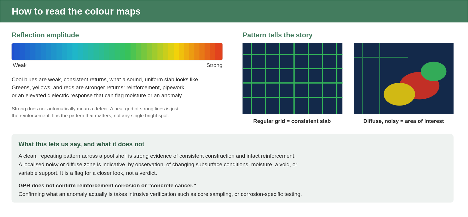 Reading The Data
A regular grid indicates consistent construction; a localised noisy zone is indicative, by observation, of changing subsurface conditions and flags an area for a closer look.
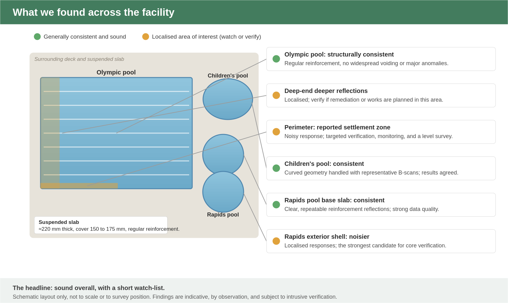
What We Found, Pool By Pool
Across the facility, the story was reassuring. Most of the structure produced clear, coherent, repeatable radar responses, consistent with well-constructed reinforced concrete and showing no evidence of widespread voiding, washout, or structural instability. The interest, where there was any, was localised.
 Findings Across The Facility
Sound overall, with a short watch-list. Schematic layout only, not to survey position.
The Detail
| Area | Overall | What We Saw | GPR / Scan Response | Recommended Next Step |
|---|---|---|---|---|
| Olympic Pool (shallow–intermediate) | Consistent | Regular reinforcement, relatively shallow cover, pipework and joints visible at depth | Clear and coherent; minor reflective patches only | None specific; routine monitoring |
| Olympic Pool deep end (200 MHz) | Watch | Localised deeper reflections; increased reflectivity beneath the deep end | Comparatively coherent overall; isolated anomalies | Verify if works or remediation are planned here |
| Olympic Pool perimeter | Watch | Aligns with the reported settlement / level-variation area | Localised noisy response; cause not confirmable by GPR alone | Targeted verification, monitoring, and a level survey |
| Suspended Slab | Consistent | Approx. 220 mm thick, cover 150–175 mm, regular reinforcement | Clear, consistent reinforcement reflections | None specific |
| Children's Pool | Consistent | Uniform shell; curved geometry limited full grid acquisition | Representative B-scans agreed with the C-scan data | None specific; monitor minor dielectric responses |
| Rapids Pool base slab | Consistent | Uniform pool-shell construction | Strong, clear, repeatable reflections | None specific |
| Rapids Pool exterior shell | Watch | Figure-eight geometry; representative B-scans used | Comparatively noisy; localised washout or void-like responses | Strongest candidate for targeted core verification |
The data did not support the fear of widespread deterioration. The Olympic pool in particular read as the most consistent of the structures, with no evidence of large voiding or major loss of support anywhere in the scanned areas.
What It Meant For The Client
The most useful finding was not a problem, it was the absence of one. The data did not support the fear of widespread deterioration. The Olympic pool in particular read as the most consistent of the structures, and there was no evidence of large voiding or major loss of support anywhere in the scanned areas. For an asset owner staring down the possibility of major intrusive works, that is a genuinely valuable result: it took the worst-case scenario off the table on the available evidence.
That said, an honest assessment does not hand over a clean bill of health from non-destructive data alone, and we did not. Three localised areas earned a place on a watch-list: the deeper reflections toward the Olympic pool deep end, the noisy response along the perimeter where settlement had been reported, and the comparatively noisy exterior shell of the rapids pool. The perimeter response is the one most relevant to the council's original concern. GPR cannot tell us whether that level variation came from historical settlement, construction tolerances, infiltration, or ground movement, only that conditions there differ from the surrounding perimeter. Confirming the cause needs a closer look, and where movement is involved that means a structural engineer and a formal level survey, not a radar report.
The Path Forward
Rather than a blanket recommendation to investigate everything, the findings supported a proportionate, staged plan:
- Hold off on broad intrusive works. The data does not justify widespread coring across the Olympic, children's, or rapids base slabs.
- Verify the watch-list, if and when it matters. Targeted core sampling or localised verification at the Olympic perimeter settlement zone, the deep end, and the rapids exterior shell, prioritised if movement continues or works are planned there.
- Bring in an engineer for the movement question. A structural engineering assessment and a level survey to determine whether active settlement is occurring at the reported perimeter zone.
- Monitor the interfaces. Keep waterproofing, perimeter joints, drainage, and overflow systems maintained, these are the usual moisture pathways in aquatic structures, and watch the settlement-prone perimeter for changes in level, cracking, or drainage behaviour.
- Use corrosion-specific testing if needed. If reinforcement corrosion or "concrete cancer" is suspected, half-cell potential testing or targeted verification is the right tool, GPR cannot confirm corrosion on its own.
Why This Matters
Non-destructive investigation is often framed as a way to find problems. Just as often, its value is the opposite: confirming that a structure is sound, and replacing a vague, expensive worry with a short, specific list of things to check. For a council managing a busy public facility on a budget, knowing where not to spend is worth as much as knowing where to.
Frequently Asked Questions
Yes. The whole survey is carried out on the surface of the drained pool shell and surrounding slab, with no coring, cutting, or drilling. It is best done while the pool is drained for maintenance, as it was here.
Reinforcement layout and cover, slab thickness, pipework and joints, and changes in the material below, such as voiding, washout, moisture-affected zones, or loss of support. Reaching different depths takes different antenna frequencies, which is why we pair high-frequency scanning with dual-frequency GPR.
No, not directly. GPR maps the reinforcement and flags changes in the concrete, but confirming corrosion or "concrete cancer" requires corrosion-specific methods such as half-cell potential testing, or intrusive verification.
Curved and figure-eight pool geometry, plus the lack of satellite positioning indoors, can prevent a complete georeferenced grid. In those areas we collect representative linear B-scans, which here agreed with the broader grid data.
It can show that conditions beneath a settlement zone differ from the surroundings, which is a strong pointer, but it cannot confirm the cause. Determining whether settlement is active needs a structural engineer and a level survey.