When it comes to Ground Penetrating Radar (GPR), one size does not fit all. That’s especially true when you’re scanning a polished concrete slab in a Sunshine Coast café one day and searching for buried utilities under compacted clay in Brisbane’s outer suburbs the next. The key to successful subsurface investigations lies in understanding antenna frequency - the “engine” behind your GPR unit. Just like choosing the right lens for a camera, selecting the correct frequency determines how deep you can see and how clearly you can resolve what’s there. Welcome to the world of multi-frequency GPR, where experience, judgement, and the right tools converge to give clients across Queensland the accurate data they need - whether it’s slab integrity, reinforcement layout, or deep soil anomalies.
What Does GPR Frequency Actually Mean?
In simple terms, GPR works by sending electromagnetic pulses into the ground and capturing the echoes that bounce back. The frequency of the antenna, measured in megahertz (MHz), affects two crucial things:
- Depth of penetration
- Resolution (detail) of the target
Lower frequencies travel deeper into the ground but produce coarser images, while higher frequencies give you finer detail – but only at shallow depths.
Here’s a quick breakdown:
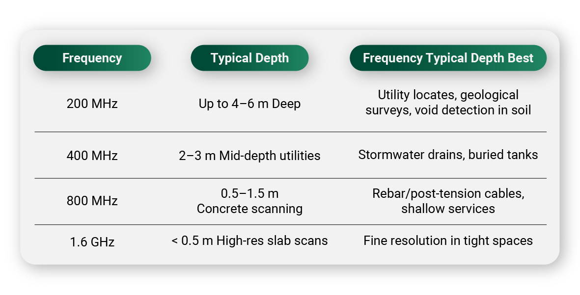
Knowing when (and where) to use these frequencies is what separates hobby scanners from professionals. At South-East Scanning, we’re trained to adapt frequencies based on soil conditions, slab thickness, and your scanning objective.
From Concrete Slabs…
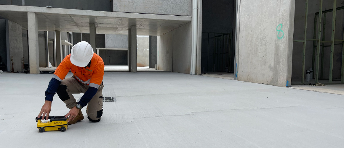
Let’s start with what most people recognise: GPR concrete scanning.
When scanning for rebar, post-tension cables, conduits or slab thickness, we typically use 800 MHz or 1.6 GHz antennas. These higher frequencies provide the necessary resolution to distinguish between close-proximity targets, ideal for structural investigations before coring or cutting.
You’ll find us using these frequencies in:
- Brisbane CBD tower refurbishments
- Sunshine Plaza retail fit-outs
- Gold Coast office renovations
These high-frequency antennas enable precise marking of utilities to within millimetres, thereby helping to avoid costly and dangerous hits during drilling or demolition.
…to Soil and Subsurface Investigations
On the flip side, if you’re investigating large, buried utilities, voids, tanks or geotechnical features, you’ll need to go deeper – and that means using a lower frequency like 200 MHz or 400 MHz.
These antennas are essential for:
- Locating sewer mains in rural development sites
- Scanning old landfill areas for buried drums or waste
- Detecting sinkholes or voids under roadways
- Mapping buried stormwater systems on infrastructure projects
The trade-off? You get less image resolution, but far deeper penetration – sometimes up to 6 metres depending on soil type.
Soil Type Matters: Not All Ground Is Equal
Here’s something clients often overlook – not all soil is GPR-friendly.
Sandy, dry soils (like much of the Sunshine Coast hinterland) are ideal. But clay-rich or saline soils, often found in coastal Gold Coast areas or reclaimed industrial land around the Brisbane River, can attenuate (weaken) the radar signal. In these cases, choosing the right frequency – and adjusting gain settings – can make the difference between a successful scan and inconclusive data.
Our technicians are trained to recognise these conditions and adapt in real time. This is where experience truly matters.
Multi-Frequency Systems: The Best of Both Worlds
Some GPR units, like the IDS Stream DP or Mala HDR, allow for dual- or multi-frequency scanning – combining low and high frequencies in one pass. This gives us both broad overviews and fine detail – perfect for complex sites where multiple underground features exist at varying depths.
Imagine scanning a railway corridor for ballast fouling (deep), while also needing to map signalling cables (shallow). A multi-frequency GPR system can deliver both datasets simultaneously.
Deliverables That Make Sense
What good is data if you can’t read it?
At South-East Scanning, we convert our radargrams into annotated PDFs, CAD layers, depth slices, and even 3D visualisations. And yes – we can explain what those fuzzy lines mean. Whether you’re a builder, engineer, council officer, or asset manager, our goal is simple: make subsurface data clear, actionable, and safe to build on.
Why Frequency Choice Matters to You
Choosing the right frequency isn’t a technical detail – it’s the foundation of project safety and success. Use the wrong one, and you might:
- Miss a buried conduit or pipe
- Misjudge slab depth
- Fail to detect a critical void
- Spend thousands rectifying avoidable mistakes
With South-East Scanning, you’re getting more than equipment – you’re getting judgement, experience, and precision from slab to soil.
Final Thought
Whether you’re coring through concrete in Brisbane’s skyline or trenching a new line in the Sunshine Coast hinterland, GPR scanning is only as good as the frequency behind it. Make sure yours is right for the job.
We’re ready to help you scan smarter, safer, and deeper – with frequency.