Flooding is one of the most devastating natural disasters, causing billions of dollars in damage and disrupting communities worldwide. In regions like Brisbane and the Sunshine Coast, where heavy rainfall and coastal influences can lead to flash floods, understanding how water moves beneath the surface is critical for flood prevention and mitigation. This is where Ground-Penetrating Radar (GPR) plays a game-changing role. By detecting underground water channels, voids, and soil saturation levels, GPR provides non-destructive, real-time insights that help engineers, councils, and construction teams make informed decisions about drainage, infrastructure, and flood preparedness. At South-East Scanning, we use advanced GPR technology to assist in flood management efforts. This technology helps us identify hidden water pathways and subsurface risks before they cause major problems.

Why Understanding Subsurface Water Matters
Water doesn’t just flow above ground and moves below the surface through natural underground streams, porous soils, and hidden voids. If these subsurface conditions aren’t properly assessed, they can lead to:
✔ Unexpected flooding due to rising water tables.
✔ Erosion and sinkholes forming beneath roads and buildings.
✔ Drainage failures caused by clogged or misaligned water pathways.
✔ Weakened infrastructure, leading to pavement cracks, foundation shifts, or collapse.
By detecting where water is pooling or flowing underground, GPR helps prevent these risks and allows engineers to design more innovative flood control systems.

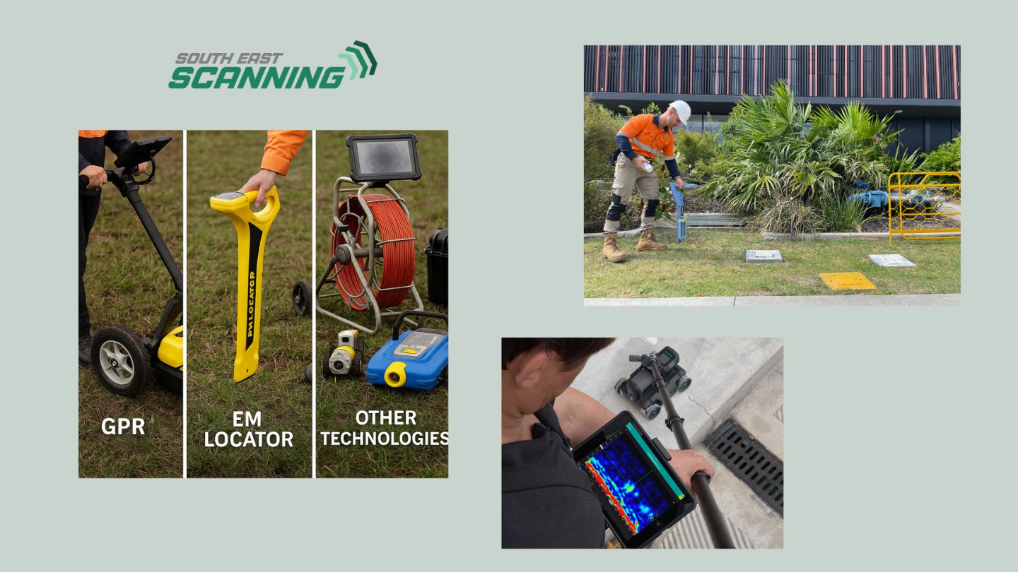
How GPR Works for Subsurface Water Detection
GPR works by transmitting high-frequency radar waves into the ground. These waves bounce back when encountering different materials, such as soil, rock, or water. Since water alters the way radar signals behave, GPR can accurately detect:
🔹 Saturated soils or high water tables that indicate potential flooding risks.
🔹 Underground water channels that may contribute to drainage issues.
🔹 Voids or sinkholes that form due to excessive water erosion.
🔹 Leaking underground pipes that may be adding to subsurface water buildup.
GPR provides a cost-effective and efficient way to map underground water movement by scanning large areas quickly and without the need for excavation.
Applications of GPR in Flood Prevention & Management
1. Urban Drainage Planning
Effective stormwater management is crucial in cities like Brisbane, where rapid urbanisation has altered natural water flow. GPR can be used to:
✔ Assess soil saturation before new developments.
✔ Locate natural underground water channels that need redirection.
✔ Identify areas where water might pool under roads or pavements, preventing future subsidence.
2. Identifying Erosion and Sinkhole Risks
Heavy rainfall and underground water flow can erode soil, creating dangerous voids beneath roads, buildings, and public infrastructure. GPR scans help detect early signs of erosion, allowing councils and construction teams to reinforce weak areas before they collapse.
3. Monitoring Flood-Prone Areas
Some locations, particularly low-lying coastal areas, are naturally prone to flooding. GPR allows for regular monitoring of groundwater levels, helping predict when and where flooding might occur. This data enables engineers to:
✔ Design better flood barriers and retention basins.
✔ Improve stormwater drainage systems.
✔ Develop proactive flood warning systems based on subsurface water movement.
4. Assessing Infrastructure After Flooding
After a significant flood, GPR can assess the damage beneath the surface, checking for:
✔ Soil washouts that have left roads unstable.
✔ Damage to building foundations from prolonged water exposure.
✔ Blocked or shifted stormwater pipes needing repair.
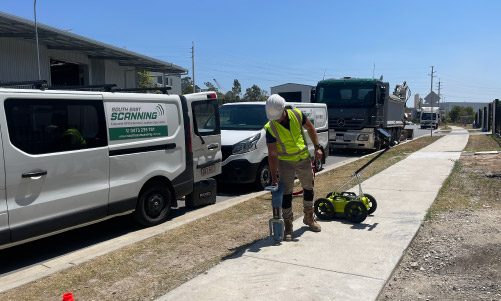
How South-East Scanning Helps in Flood Management
At South-East Scanning, we work with engineers, councils, and construction teams to provide detailed GPR scans that uncover hidden subsurface water risks. Whether it’s detecting underground drainage issues before a new development or assessing flood damage after heavy rains, our expertise ensures that critical decisions are based on accurate, real-time data.
We bring cutting-edge GPR technology to projects across Brisbane, the Sunshine Coast, and South East Queensland, helping create safer, more flood-resilient communities.

Why GPR Technology is a Game-Changer
The benefits of using GPR technology in safety inspections are manifold. For starters, GPR offers a non-invasive way to assess subsurface conditions, preserving the integrity of the site while providing critical data. This is particularly important in preserving historical sites and environmentally sensitive areas.
In addition to safety, GPR is cost-effective and time-saving. Conducting a GPR scan is faster and often cheaper than traditional exploratory methods, allowing projects to stay on schedule and within budget. This efficiency is a significant advantage for safety inspectors tasked with managing tight timelines.
GPR technology also enhances safety inspectors’ ability to foresee potential hazards. By detecting issues before they become problems, inspectors can implement preventive measures, reducing the risk of accidents and enhancing overall safety on-site.
Conclusion
Flood management isn’t just about surface drainage—what’s happening underground is just as important. GPR is revolutionising flood prevention and mitigation by allowing engineers to see subsurface water movement without excavation.
Flooding is one of the most devastating natural disasters, causing billions of dollars in damage and disrupting communities worldwide. In regions like Brisbane and the Sunshine Coast, where heavy rainfall and coastal influences can lead to flash floods, understanding how water moves beneath the surface is critical for flood prevention and mitigation. This is where Ground-Penetrating Radar (GPR) plays a game-changing role. By detecting underground water channels, voids, and soil saturation levels, GPR provides non-destructive, real-time insights that help engineers, councils, and construction teams make informed decisions about drainage, infrastructure, and flood preparedness. At South-East Scanning, we use advanced GPR technology to assist in flood management efforts. This technology helps us identify hidden water pathways and subsurface risks before they cause major problems.
Why Understanding Subsurface Water Matters
ater doesn’t just flow above ground and moves below the surface through natural underground streams, porous soils, and hidden voids. If these subsurface conditions aren’t properly assessed, they can lead to:
✔ Unexpected flooding due to rising water tables.
✔ Erosion and sinkholes forming beneath roads and buildings.
✔ Drainage failures caused by clogged or misaligned water pathways.
✔ Weakened infrastructure, leading to pavement cracks, foundation shifts, or collapse.
By detecting where water is pooling or flowing underground, GPR helps prevent these risks and allows engineers to design more innovative flood control systems.
How GPR Works for Subsurface Water Detection
GPR works by transmitting high-frequency radar waves into the ground. These waves bounce back when encountering different materials, such as soil, rock, or water. Since water alters the way radar signals behave, GPR can accurately detect:
🔹 Saturated soils or high water tables that indicate potential flooding risks.
🔹 Underground water channels that may contribute to drainage issues.
🔹 Voids or sinkholes that form due to excessive water erosion.
🔹 Leaking underground pipes that may be adding to subsurface water buildup.
GPR provides a cost-effective and efficient way to map underground water movement by scanning large areas quickly and without the need for excavation.
Applications of GPR in Flood Prevention & Management
Effective stormwater management is crucial in cities like Brisbane, where rapid urbanisation has altered natural water flow. GPR can be used to:
✔ Assess soil saturation before new developments.
✔ Locate natural underground water channels that need redirection.
✔ Identify areas where water might pool under roads or pavements, preventing future subsidence.
1. Urban Drainage Planning
Effective stormwater management is crucial in cities like Brisbane, where rapid urbanisation has altered natural water flow. GPR can be used to:
✔ Assess soil saturation before new developments.
✔ Locate natural underground water channels that need redirection.
✔ Identify areas where water might pool under roads or pavements, preventing future subsidence.
2. Identifying Erosion and Sinkhole Risks
Heavy rainfall and underground water flow can erode soil, creating dangerous voids beneath roads, buildings, and public infrastructure. GPR scans help detect early signs of erosion, allowing councils and construction teams to reinforce weak areas before they collapse.
3. Monitoring Flood-Prone Areas
Some locations, particularly low-lying coastal areas, are naturally prone to flooding. GPR allows for regular monitoring of groundwater levels, helping predict when and where flooding might occur. This data enables engineers to:
✔ Design better flood barriers and retention basins.
✔ Improve stormwater drainage systems.
✔ Develop proactive flood warning systems based on subsurface water movement.
4. Assessing Infrastructure After Flooding
After a significant flood, GPR can assess the damage beneath the surface, checking for:
✔ Soil washouts that have left roads unstable.
✔ Damage to building foundations from prolonged water exposure.
✔ Blocked or shifted stormwater pipes needing repair.
How South-East Scanning Helps in Flood Management
At South-East Scanning, we work with engineers, councils, and construction teams to provide detailed GPR scans that uncover hidden subsurface water risks. Whether it’s detecting underground drainage issues before a new development or assessing flood damage after heavy rains, our expertise ensures that critical decisions are based on accurate, real-time data.
We bring cutting-edge GPR technology to projects across Brisbane, the Sunshine Coast, and South East Queensland, helping create safer, more flood-resilient communities.
Why GPR Technology is a Game-Changer
The benefits of using GPR technology in safety inspections are manifold. For starters, GPR offers a non-invasive way to assess subsurface conditions, preserving the integrity of the site while providing critical data. This is particularly important in preserving historical sites and environmentally sensitive areas.
In addition to safety, GPR is cost-effective and time-saving. Conducting a GPR scan is faster and often cheaper than traditional exploratory methods, allowing projects to stay on schedule and within budget. This efficiency is a significant advantage for safety inspectors tasked with managing tight timelines.
GPR technology also enhances safety inspectors’ ability to foresee potential hazards. By detecting issues before they become problems, inspectors can implement preventive measures, reducing the risk of accidents and enhancing overall safety on-site.
Conclusion
Flood management isn’t just about surface drainage—what’s happening underground is just as important. GPR is revolutionising flood prevention and mitigation by allowing engineers to see subsurface water movement without excavation.