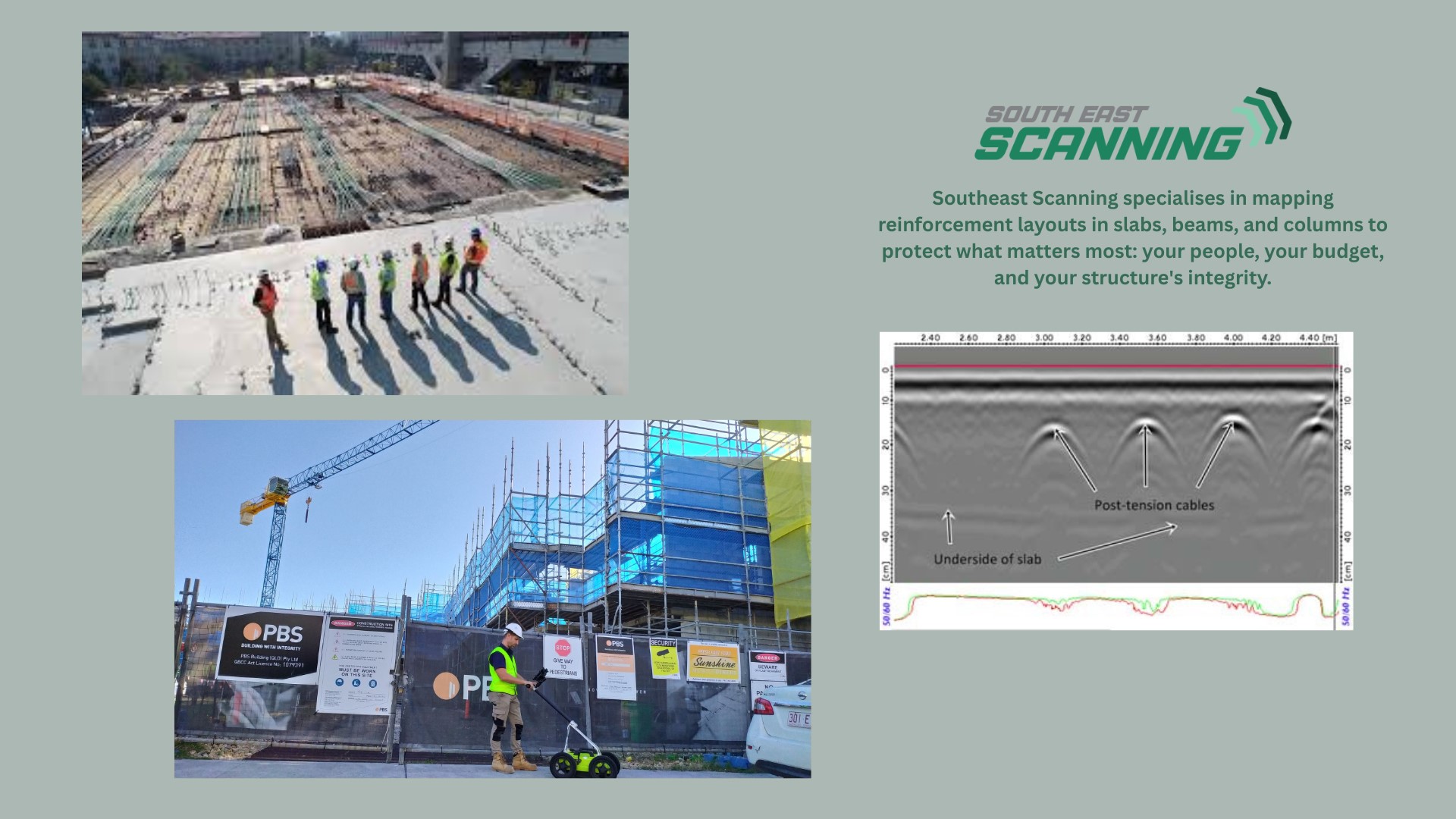
Utility locating is an essential process in construction, maintenance, and infrastructure projects. It ensures that underground utilities such as electrical lines, gas pipelines, and telecommunications cables are accurately identified and mapped to prevent accidental damage during excavation. Among the various technologies used for utility locating, electromagnetic induction (EMI) has seen significant advancements in recent years, leading to improved precision and efficiency.
Understanding Electromagnetic Induction Technology
Electromagnetic induction technology relies on the principles of electromagnetism to detect underground utilities. It involves the use of a transmitter and a receiver. The transmitter emits an electromagnetic signal that induces a current in the buried utility, which in turn generates its own electromagnetic field. The receiver detects this field, allowing the operator to trace the path of the utility.
This non-invasive method is widely used due to its ability to locate conductive utilities, such as metal pipes and electrical cables, with a high degree of accuracy. Recent advancements in EMI technology have further enhanced its capabilities, making it a more reliable and efficient tool for utility locating.
Key Advances in Electromagnetic Induction Technology
- Improved Signal Strength and Clarity: One of the significant advancements in EMI technology is the enhancement of signal strength and clarity. Modern transmitters are now capable of generating stronger and more stable signals, which can penetrate deeper into the ground and provide clearer readings. This improvement reduces the likelihood of false positives and ensures that even utilities buried at greater depths can be accurately detected.
- Multi-Frequency Capabilities: Traditional EMI devices typically operated at a single frequency, which could limit their effectiveness in certain conditions. Contemporary EMI locators are equipped with multi-frequency capabilities, allowing operators to switch between different frequencies depending on the type of utility and soil conditions. This flexibility enhances the locator’s ability to distinguish between multiple utilities and reduces interference from external sources.
- Advanced Filtering and Noise Reduction: Modern EMI locators incorporate advanced filtering and noise reduction technologies that help eliminate background noise and interference from other electromagnetic sources. This advancement is particularly useful in urban environments where multiple signals from various sources can complicate the locating process. By filtering out unwanted noise, these devices provide more accurate and reliable readings.
- Enhanced Data Integration and Visualisation: The integration of advanced data processing and visualisation tools has transformed the way utility locating data is interpreted. Many modern EMI locators now come with built-in GPS and Bluetooth capabilities, allowing real-time data transfer to mapping software and mobile devices. This integration facilitates the creation of detailed and precise utility maps, which can be used for planning and documentation purposes. The ability to visualise data in real-time improves decision-making and enhances the overall efficiency of the locating process.
- User-Friendly Interfaces and Automation: User-friendly interfaces and automation features have made EMI locators more accessible to operators with varying levels of experience. Touchscreen displays, intuitive controls, and automated functions such as self-calibration and automatic gain control simplify the operation of these devices. These advancements reduce the learning curve and ensure consistent and accurate results, regardless of the operator’s skill level.
Specific Technology: The Pipehorn Series
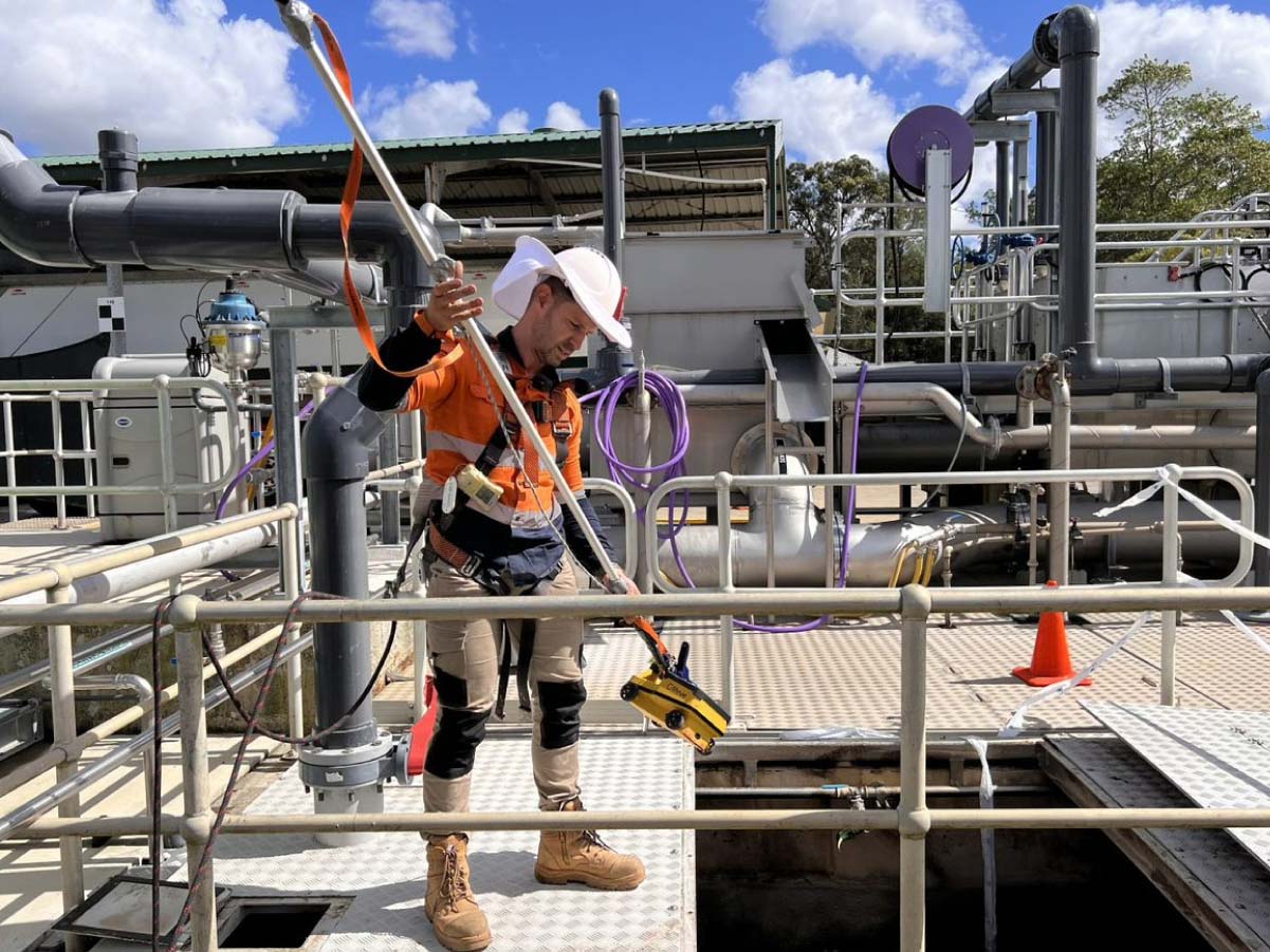
One notable example of advanced EMI technology is the Pipehorn series of locator wands. The Pipehorn 800 Series, for instance, is designed to offer superior performance in locating both conductive and non-conductive utilities. These devices are equipped with dual-frequency capabilities, allowing operators to switch between high and low frequencies to adapt to different locating scenarios.
The Pipehorn 800 Series employs advanced filtering and noise reduction techniques to provide clear and reliable readings, even in environments with significant electromagnetic interference. The devices also feature ergonomic designs and intuitive interfaces, making them easy to use for both novice and experienced operators.
How Pipehorn Works
The Pipehorn transmitter sends out a powerful signal that can penetrate deep into the ground. When the signal encounters a buried utility, it induces a current in the utility, which then emits its own electromagnetic field. The Pipehorn receiver detects this field and translates it into visual and auditory signals that guide the operator in tracing the utility’s path. The dual-frequency capability allows the operator to choose the best frequency for the specific conditions, enhancing the accuracy of the locating process.

Real-Life Examples
Urban Infrastructure Upgrade
In a recent project to upgrade urban infrastructure in Brisbane, the use of the Pipehorn 800 Series proved invaluable. The project involved replacing old water and gas pipelines in a densely populated area with numerous overlapping utilities. The Pipehorn’s dual-frequency capability allowed the operators to differentiate between the various utilities accurately. Its advanced noise reduction features helped eliminate interference from nearby electrical sources, ensuring precise location of the target utilities.
Rural Telecommunications Installation
In another case, a telecommunications company was installing new fibre optic cables in a rural area with challenging soil conditions. The Pipehorn 800 Series’ ability to switch between high and low frequencies enabled the team to locate existing underground utilities accurately, despite the varied soil composition. This capability prevented accidental damage to existing infrastructure and ensured a smooth installation process.
The Impact on Precision and Efficiency
The advancements in electromagnetic induction technology have had a profound impact on the precision and efficiency of utility locating. Enhanced signal strength and clarity, combined with multi-frequency capabilities, allow for the accurate detection of a wide range of utilities, including those that are deeply buried or located in challenging soil conditions. Advanced filtering and noise reduction ensure that readings are reliable, even in noisy environments.
The integration of GPS and data visualisation tools streamlines the process of creating and maintaining utility maps, making it easier for project managers to plan and execute their projects. User-friendly interfaces and automation features not only improve the accuracy of locating operations but also reduce the time and effort required to complete them.
As the demand for accurate and efficient utility locating continues to grow, the advancements in electromagnetic induction technology are playing a crucial role in meeting this demand. Innovations like the Pipehorn 800 Series are enhancing the precision and reliability of utility locating operations, minimising the risk of accidental damage, and contributing to safer and more efficient infrastructure projects. At South-East Scanning, we are committed to staying at the forefront of these technological advancements, ensuring that our clients benefit from the latest and most effective utility locating solutions available. Get in contact with us today to discuss your project – we’re excited to help you!