Locating The Unknown:
Utility Detection Before
The Drill Goes In
Before a signage installation across a busy civic precinct, South East Scanning located every underground service by GPR and electromagnetic methods, then graded each one against AS5488 — including a shallow sewer hazard that needed flagging, not guessing.
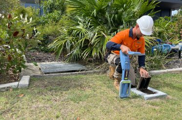
Driving a signpost into the ground sounds simple. On a busy civic precinct, with power, comms, water, stormwater and sewer all threaded beneath the surface, it is anything but. Hit a live service and a routine signage job becomes an outage, an injury, or a very expensive repair. Hutchinson Builders engaged South East Scanning to make sure that did not happen at the Gympie Civic Centre, by finding out what was underground before any footing went in.
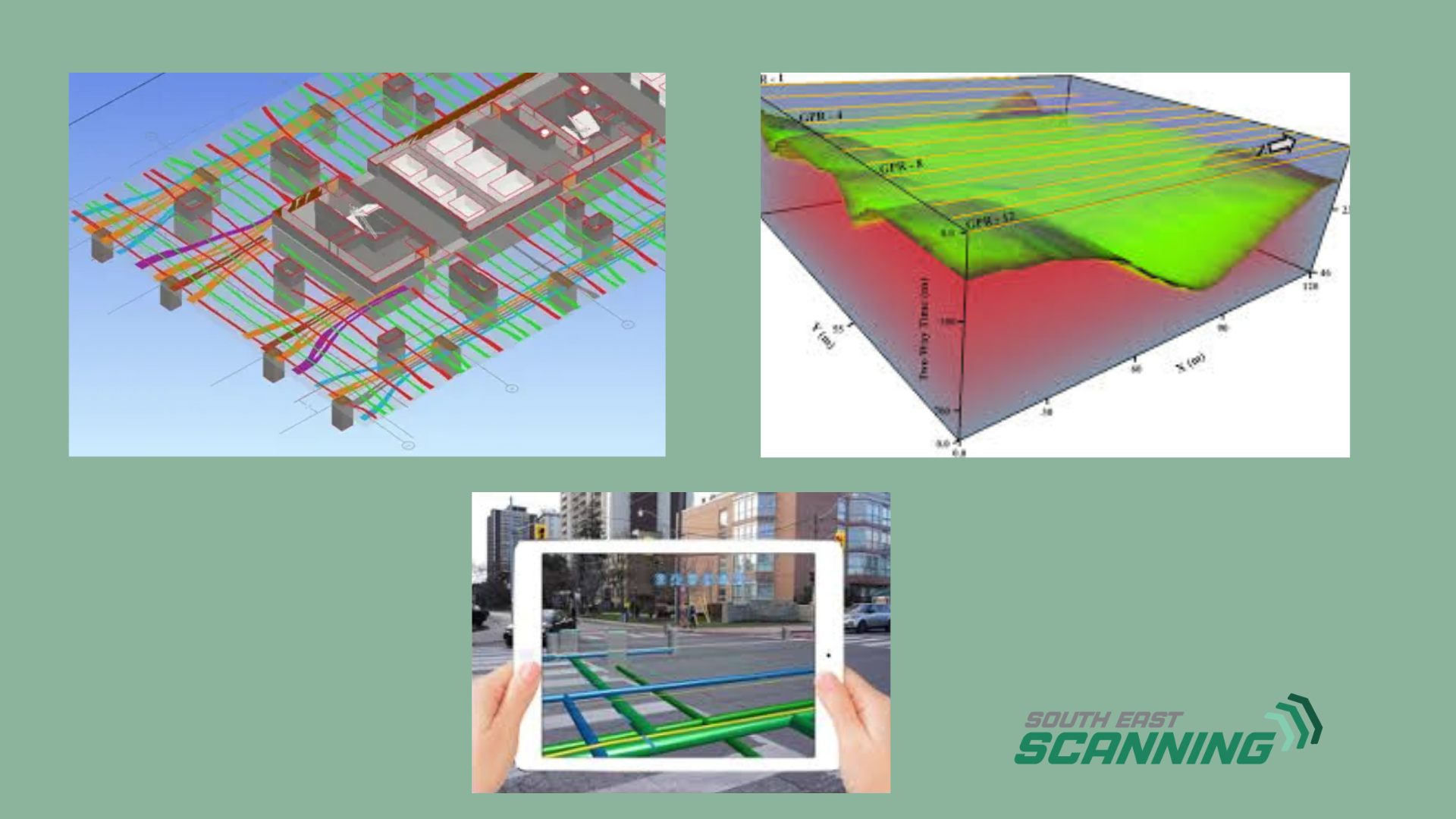
On the inspection date, we located the site's underground services using non-destructive methods — Ground Penetrating Radar and electromagnetic locating — and classified every find against the Australian Standard for subsurface utility information, AS5488. The result is not just a map of where things are. It is an honest, graded account of how confident we are in each location, which is exactly what a builder needs to dig safely.
Confidence, Not Just Position: AS5488 Explained
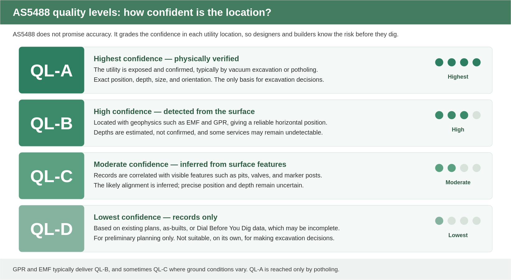
Here is the idea that makes a locate report genuinely useful. A utility plan that simply draws a line on a map invites false confidence. AS5488 does something more honest: it grades the reliability of each location, so designers and builders understand the risk before they dig. It defines four quality levels, from QL-D, the lowest confidence, up to QL-A, the highest.
 AS5488 Quality Levels — QL-A to QL-D
AS5488 quality levels. GPR and EMF typically deliver QL-B, and may be QL-C where ground conditions vary; only potholing reaches QL-A.
Reading our plans is then straightforward. Each utility is annotated with the service, an indicative depth, and its quality level — for example, electricity at 0.6 to 0.8 m, classified QL-B. The quality level tells you how far to trust the line. A QL-B alignment is a reliable horizontal position with an estimated depth; a QL-D line is records-based and should be treated as a rough guide only, not a basis for excavation.
What We Located Across The Site
We mapped the services threading through the works area, with the confidence we could reasonably assign to each. Some came back clean. Several, importantly, did not — and we said so plainly rather than dressing up a guess as a result.
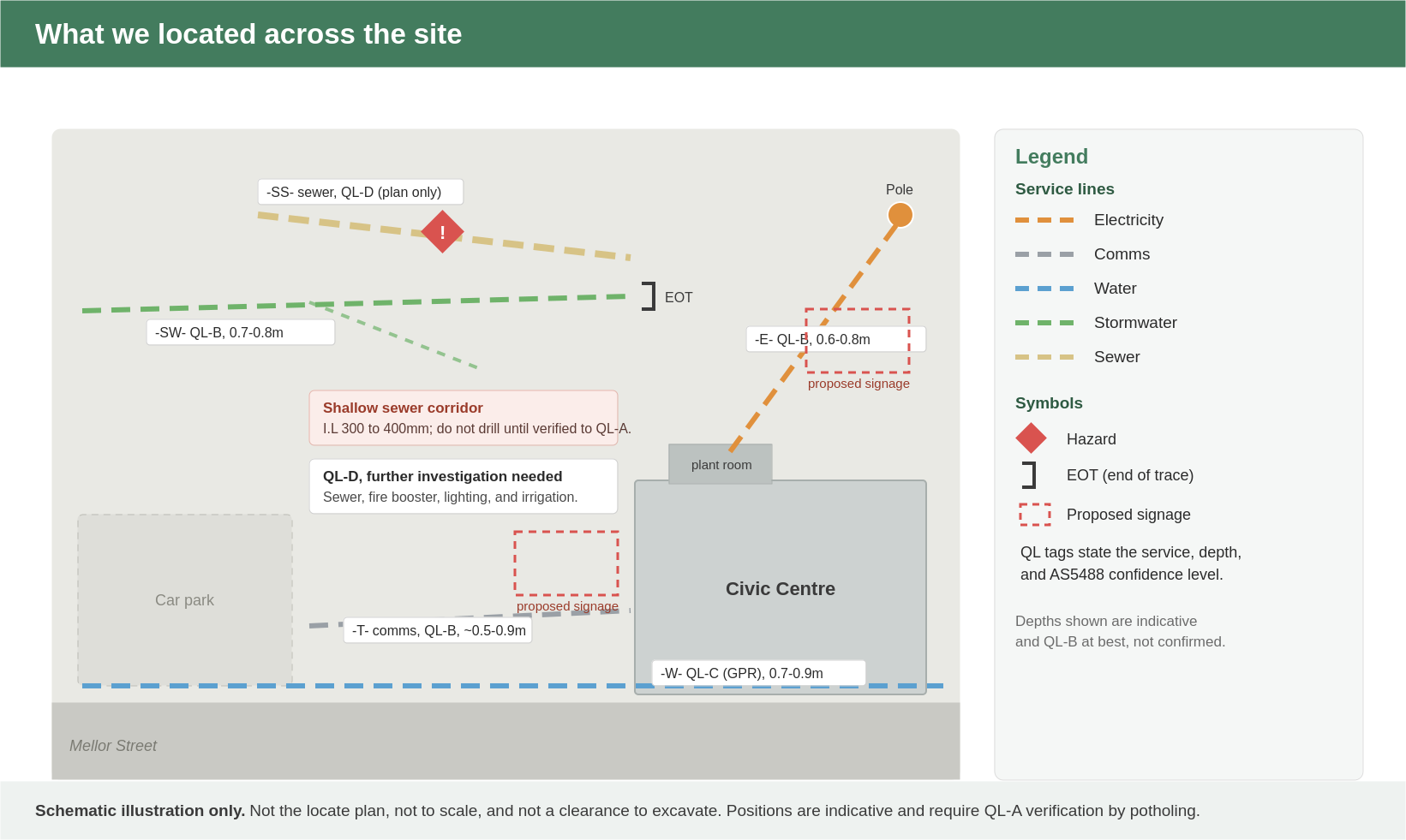 Utilities Located Across The Civic Precinct
The kind of picture we build: services colour-coded by type, each carrying its AS5488 confidence level, with hazards and end-of-trace points marked. Schematic illustration only, not the locate plan.
The Detail
| Service | Quality Level | Depth (Indicative) | Method | What We Found, And The Caveat |
|---|---|---|---|---|
| Electricity | QL-B | 0.6–0.8 m | EMF | Mains run from the pole into the plant room; horizontal position reliable, depth estimated. |
| Comms | QL-B | ~0.5–0.9 m | EMF | Located through the works area; positively identify to QL-A before drilling, do not rely on the general depth limit here. |
| Water | QL-C | 0.7–0.9 m | GPR | Alignment indicated by GPR; position approximate, depth not confirmed. |
| Stormwater | QL-B / QL-C | 0.7–0.8 m | GPR | Part traced to QL-B; elsewhere GPR was inconclusive, so the line follows surface alignments and visible concrete cuts (QL-C). One run hit a strong signal impediment and could not be traced beyond that point (EOT). |
| Sewer | QL-D | I.L. 300–400 mm (shallow) | Records | Plan only; the site did not confirm the pit or line. A shallow sewer corridor is a real hazard; do not drill until verified to QL-A. |
| Fire / Hydraulic Booster | QL-D | Not available | — | No plans; the booster box must be opened and details sought from Council or the installer. Site conditions were unsuitable for GPR. |
| Lighting | QL-D | Not available | EMF (failed) | Connecting cables are not earthed, so the EMF trace was unsuccessful; conduit path needs further investigation. |
| Irrigation | QL-D | Not available | EMF (failed) | Lines are not connected via solenoids; further investigation required to trace satisfactorily. |
A locate report that only showed the easy wins would have been dangerously incomplete. Flagging the sewer, booster, lighting and irrigation as unconfirmed is the honest, safe answer, and it tells the builder exactly what still needs verifying before work proceeds.
Digging Safely: How To Use This Plan
A locate plan is a risk-management tool, not a green light. Because most of the positions are QL-B at best, and several are QL-D, the plan reduces risk but does not, on its own, clear the ground for excavation. We set out clear rules for using it, anchored in the FIVE P's of safe digging.
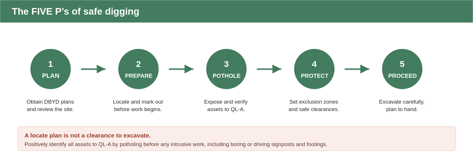 The Five P's of Safe Digging
The FIVE P's of safe digging: PLAN, PREPARE, POTHOLE, PROTECT, PROCEED. Potholing to QL-A is the step that turns an indicative line into a confirmed one.
For this site specifically, the guidance was layered:
- Pothole to QL-A before any intrusive work. Before boring or driving signposts and footings, positively identify all assets in the vicinity by potholing.
- A 400mm depth limit as a secondary control only. In areas clear of all marked assets, drilling was limited to 400 mm as a risk-reduction measure. It is not a clearance, it does not override the need to pothole, and it does not apply within 500 mm of any marked asset.
- No drilling in the shallow sewer corridor. With the sewer as shallow as 300 to 400 mm, work must not proceed there until the asset is positively identified to QL-A.
- Cross-reference before relying on any single line. Given the area covered, the site markings should be read alongside the site photographs in the report rather than any one annotation in isolation.
Why This Matters
It is tempting to judge a locate job by how many services it finds. The better measure is how clearly it communicates risk. On this site, the value was twofold: a reliable, confidence-graded picture of the services we could trace, and an honest, specific list of the ones that still needed verifying — including a shallow sewer that could have turned a signpost into an incident. That is the difference between a map and a safe set of instructions.
Frequently Asked Questions
AS5488 is the Australian Standard for classifying subsurface utility information. It does not promise accuracy; it grades the confidence in each utility location, from QL-D (records only) to QL-A (physically verified). That grading lets designers and builders judge the risk before they dig.
No. A locate plan shows where services are likely to be, at a stated confidence. It is a risk-management tool, not a clearance. Before excavation, assets should be positively identified to QL-A by potholing.
QL-D is the lowest confidence, based on records or limited surface indications. It is fine for preliminary planning, but not, on its own, a basis for excavation decisions. On this site, the sewer, fire booster, lighting and irrigation were QL-D and flagged for further investigation.
Detection has limits. EMF needs a traceable, often earthed or connected conductor, so the lighting (not earthed) and irrigation (no solenoids) traces were unsuccessful. GPR can be defeated by ground conditions or signal impediments, which is why one stormwater run ended at an EOT, an end-of-trace point. We report these honestly rather than guessing.
Follow the FIVE P's: PLAN, PREPARE, POTHOLE, PROTECT, PROCEED. In short, get and review your DBYD plans, mark out, pothole to expose and confirm assets to QL-A, set safe clearances, and only then excavate, with the plan to hand.